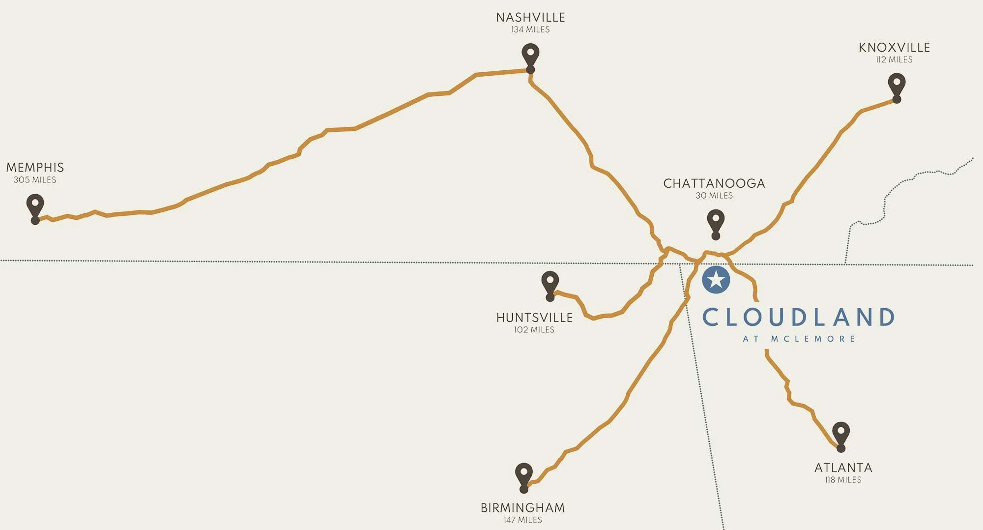
Location and directions
Location & Directions to Cloudland Resort
Conveniently located near several major metropolitan areas, Cloudland is a short drive away for anyone seeking a golf resort, romantic getaway, seamless meeting/event, or a family vacation. Enjoy an array of culinary experiences from The Croft, Auld Alliance, and The Pocket Cafe. When not on the green, choose from an array of activities like hiking to nearby waterfalls, taking in a sunrise yoga class, hang-gliding amongst the clouds, or enjoying a relaxing massage at Selah Spa. See what sets us apart from other hotels near Lookout Mountain by booking a stay.
-
Directions from Chattanooga
Take W 10th St to Broad St - 42 sec (335 ft)
Take GA-193 S and GA-136 W to GA-157 S in Rising Fawn - 34 min (22.3 mi)
Continue on GA-157 S. Drive to Canyon Ridge Rd
Directions to ChattanoogaTake GA-157 N to GA-136 E - 7 min (4.3 mi)
Take GA-193 N to W 10th St in Chattanooga - 34 min (22.3 mi)
Continue on W 10th St to your destination
Directions from Chattanooga AirportTake TN-153 S - 3 min (1.2 mi). Continue on TN-153 S.
Take I-75 S to GA-146 W/Cloud Springs Rd in Catoosa County.
Take exit 353 from I-75 S - 7 min (6.8 miles). Use the right 2 lanes to turn right onto GA-146 W/Cloud Springs Rd - 8 min (4.4 miles).
Continue on Lafayette Rd to GA-2 W/Battlefield Pkwy - 2 min (1.0 miles). Keep left to continue on GA-2 W/Battlefield Pkwy - 6 min (4.2 miles).
Continue on GA-193 S to Rising Fawn - 20 min (15.2 miles). Continue on GA-157 S. Drive to Canyon Ridge Rd
Directions to Chattanooga Int’l AirportTake GA-157 N to GA-136 E - 7 min (4.3 mi)
Take GA-193 N to GA-2 E/Battlefield Pkwy - 19 min (15.1 mi)
Take I-75 N in Catoosa County from Battlefield Pkwy and GA-146 E/Cloud Springs Rd – 16 min (9.5 mi)
Continue on I-75 N. Take TN-153 N to Airport Connector Rd/W Shepherd Rd in Chattanooga. Take exit 1A from TN-153 N - 7 min (6.8 mi)
Drive to Airport Connector Rd
-
Directions from Huntsville
Take I-565 E from Spragins St SW - 4 min (1.2 miles)
Take US-72 E and AL-40 E to Co Rd 631 in Mentone - 1 hr 20 min (72.9 miles)
Take GA-157 N to Canyon Ridge Rd in Rising Fawn - 24 min (17.1 miles)
Directions to HuntsvilleTake GA-157 S to AL-117 N in Mentone - 25 min (17.1 miles)
Take AL-40 W and US-72 W to Washington St NW in Huntsville.
Take exit 19A from I-565 W - 1 hr 22 min (73.4 miles)
Take Jefferson St N to Spring St SW - 3 min (0.6 miles)
-
Directions from Atlanta
Take I-75 N/I-85 N - 1 min (0.4 miles)
Follow I-75 N to Resaca. Take exit 320 from I-75 N - 1 hr 5 min (73.1 miles)
Take GA-136 W, turn left on GA-157 S and continue to Canyon Ridge Rd in Rising Fawn -1 hr (47.6 miles)
Directions to AtlantaTake I-75 S in Resaca from GA-136 E - 1 hr (47.7 miles). I-75 S to M.L.K. Jr Dr SE in Atlanta
Take exit 248A from I-75 S/I-85 S - 1 hr 6 min (72.9 miles)
Take Capitol Sq SW to Capitol Ave SW - 1 min (0.2 miles)
-
Directions from Knoxville
Take I-40 W to I-75 S to GA 146 W/Cloud Springs Road
Take Battlefield Parkway, GA-193 S and GA-136 W, turn left on GA-157 S and continue to Canyon Ridge Road
Turn left on Canyon Ridge Road and the hotel will be on the right.
Directions to Knoxville
Turn right on GA-157 N
Turn right on GA-136 E
Turn left on GA-193 N and continue onto St. Elmo Ave
Turn right into Tennessee Ave and follow to TN-58 N
Turn left onto Alton Park Blvd and use the right lanes to merge onto 1-24E
Take I-75N to Knoxville
-
Directions from Nashville
Take I-24 E from 4th Ave S, Nolensville Pk, Glenrose Ave and Mashburn Rd - 19 min (6.2 miles)
Follow I-24 E to GA-136 E/White Oak Gap Rd in Trenton
Take exit 11 from I-59 S - 1 hr 49 min (122 miles)
Follow GA-136 E and GA-157 S to Canyon Ridge Rd in Rising Fawn - 21 min (14.0 miles)
Directions to NashvilleTake I-59 N in Trenton from GA-157 N and GA-136 W - 21 min (14.2 miles)
Follow I-24 W to George L Davis Blvd in Nashville
Take exit 209 from I-40 W - 1 hr 56 min (130 miles)
Drive to Church St - 3 min (0.6 miles)
-
Directions from Birmingham
Take I-20 E/I-59 N from Reverend Abraham Woods Jr Boulevard - 5 min (1.9 miles)
Follow I-59 N to 49th St NW in Fort Payne
Take exit 224 from I-59 N - 1 hr 24 min (97.2 miles)
Take AL-117 S, Co Rd 631 and GA-157 N to Canyon Ridge Rd in Rising Fawn - 39 min (28.2 miles)
Directions to BirminghamTake I-59 S in Fort Payne from GA-157 S, Flarity Rd, Co Rd 631, AL-117 N and Co Rd 137 - 40 min (28.6 miles)
Follow I-59 S to 6th Ave N in Birmingham. Take exit 126A from I-59 S - 1 hr 25 min (98.3 miles)
Keep left at the fork to continue on 6th Ave N - 3 min (0.7 miles)